A project has been under way for the last two years in the Anglesey Area of Outstanding
Natural Beauty supported by Cadw with accompanying educational funding from the Anglesey
AONB Sustainability Fund. It has been investigating a number of new archaeological
sites discovered through aerial photographic survey by the RCAHMW and by Pixaerial.
In 2009 a program of geophysical surveys of a selection of sites was carried out.
In May 2010 one of the sites was investigated by trial excavation to characterise
the remains, to provide dating and gather interpretative evidence and to assess their
survival and potential.
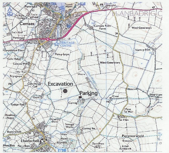
The area chosen for the field work was a sub-circular hill-top enclosure at Carrog,
Llanbadrig. The survey showed a number of internal features and was interpreted on
typological grounds as a possible Late Bronze Age or Early Iron Age defended site
(see fig.). Thanks go to the farmer Jac Jones and to the landowner Robin Grove-White
for allowing the excavation to be carried out, and to the local people who helped
on the excavation and gave encouragement.
The excavation at Carrog showed a large enclosure ditch, 4m wide and over 2m deep.
It is a surprising size considering that the whole enclosure is only 50m diameter
(see fig.). Within the enclosure were a number of small post-holes, some forming
an arc that may be the outer wall of a single large central roundhouse. Unfortunately
there were no associated datable artefacts but beneath the area of the former defensive
bank and some way beyond it were found a number of hearth pits. Some contained worked
flint and chert and distinctive pottery showing occupation of the hill-top during
the Early Neolithic period.
After the enclosure ditch had been largely silted up it had been backfilled and a
small rectangular building had been built within. Part of a flat rotary quern and
a stone loom-weight, believed to be of Romano-British date were found in this area.
The defended enclosure therefore preceded this phase by a considerable period. Its
date should be eventually determined by radiocarbon dating.
Excavations at Carrog, Update , April 2011
The small hill-top enclosure at Carrog, Llanfcehell , identified as a crop mark on
an aerial photograph, was evaluated by a small excavation in May 2010. The enclosure
was interpreted on typological grounds as a possible Late Bronze Age or Early Iron
Age defended site. This is a period for which we have very little evidence on Anglesey,
making it a possibly exciting discovery.
The excavation showed the enclosure ditch to be substantial and probably defensive
but nothing was left of any accompanying bank. Within the enclosure were numerous
post-holes and pits. Some of the pits proved to be hearths of early Neolithic date
and these have produced radiocarbon dates in the 4th millennium Cal BC. They represent
use of the hilltop as a camp-site long before the enclosure was built. There was
little artefactual evidence for the occupation of the enclosure itself but radiocarbon
dates from post-holes and from the ditch showed that it was constructed about 800
Cal BC and occupied until about 400 Cal BC. The original interpretation was therefore
confirmed, making the site one of great archaeological interest. It was built at
a time when defensive enclosures of any type were a new feature of the landscape.
It probably contained the dwelling of a local chief with e dependent farming community
in the area around, living in scattered houses. The entrances of enclosures, such
as this one, usually face south-east, and they may have had some ceremonial as well
as defensive function. One theory is that they were developed as centres where communal
cereal grain could be safely stored.
Late in its existence, after it had largely silted-up, the enclosure ditch had been
partially backfilled and a small, probably rectangular building constructed within
it. This building was probably a small house. It was associated with a rotary hand
quern and a stone loom weight and has been radiocarbon dated to the 8-9th C Cal AD.
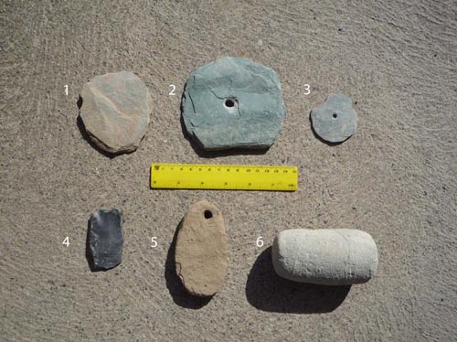
Finds from Carrog
1 - 3 Slate discs 4. Neolithic chert knife 5.
Loom weight 6. Stone pestle